Sentiers du Patrimoine ®
Nesles-la-Vallée
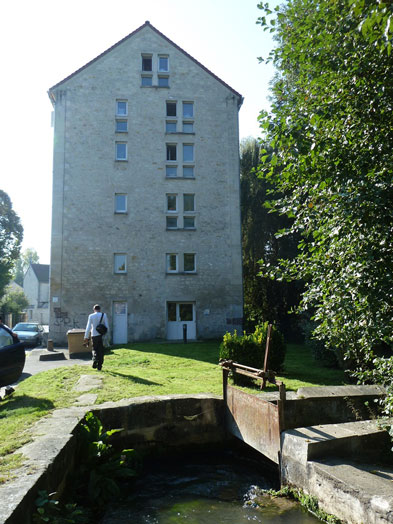
Moulin Fessart
Laisser le moulin sur la gauche, continuer sur la rue de Thiébault sur environ 200 mètres et emprunter à droite la sente du petit ru. A sa sortie, traverser avec précaution. La plaque sur le château de la Garenne se trouve à côté de l’arrêt de bus.
Prochain point : lat="49.132492" lon="2.170934"
This structure is marked on the Cassini maps, which were drawn-up in 1757-1758 and therefore dates from before this time. Widely known as the Fessart Mill, it is a flour mill with thresher. In 1806 a marker was placed upstream from the spillway to indicate the legal level of water retention, “...setting the invariable water level... in order to observe and direct the exterior system of factories and mills...” according to the official report.
The wheel has a diameter of 4.8 metres, a falling hight of 1.99 metres and an average flow calculated in 1910 at 360 litres per second.
In the 1930s, a seed store was installed in the building adjacent to the flour producing section, which made a wholemeal flour called “Les Procédés François” for delivery to Paris.
The last miller opened a small bakery, which was then moved into the mill buildings (wagon shed, stable and sheds with a hay and straw loft).
Today you can still see the spillway of the former millrace; the mill's water intake was blocked off in 1988 when the complex was converted into housing by the regional public housing office.