
Sentiers du Patrimoine ®
Montalet-le-Bois
Poursuivre jusqu’à la mairie.
Prochain point : Lat. 49.038993, Long. 1.830552
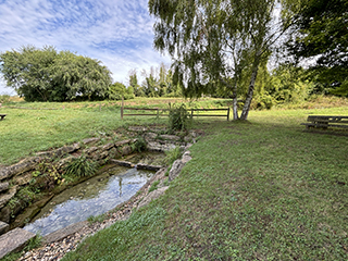
The commune of Montalet-le-Bois is defined by two watercourses: the Bernon, a tributary of the Montcient, and the Férets stream, also known as the Ravine de la Mare de Magny. The Bernon rises here, in the north-west of the commune, and is joined in the heart of the village by the Férets stream. In 1899, the village schoolmaster praised the quality of the local water: “Montalet is remarkable for its fine waters. Indeed, the village is one of the most fortunate in the region in this regard. […]. The water […] is clear and excellent for cooking and household use.”
The source of the Bernon has been used as a washhouse featuring two basins. Records from the Napoleonic cadastre indicate that this site was already a public communal fountain in 1826. This is by no means the only adaptation along the course of the Bernon. In the centre of Montalet, numerous walls and low barriers line the streets and channel water flow, while the course of the stream has been straightened by human intervention, altering its confluence with the Férets. While many of these 19th-century modifications were intended to tame the Bernon, they also created flood risks during heavy rainfall. The commune has addressed this through the construction of basins and the restoration of ponds, respecting ecological continuity.