Prochain point : lat="49.100244" lon="1.967134"

US
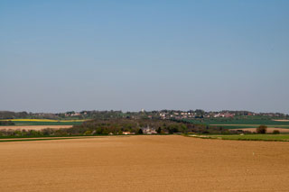
A village in the Viosne valley
A little history
The town’s name is thought to derive from the word Vicus, then Wissous, meaning “the village”. With the coming of the railway, the name was apparently simplified for passengers travelling between Paris and Dieppe. The spelling has changed over the course of the centuries, being written Uus, VVs, Hus and Ws, before finally settling on its current spelling, Us, after a meeting of the town council on February 13th, 1885. In 1954, the town decided to adopt the Dampont family shield as its emblem.
The roman roads
The old crossroads between Chaussée Jules César and Chaussée Brunehaut are located in the southern part of the commune. These two roads have marked the landscape for over 2,000 years.
The Chaussée Jules César is part of a vast network of Roman roads established during the last century BC and the first century AD. This network was designed to establish Roman authority by providing access for soldiers to expand or pacify the outer reaches of the Roman Empire, and allowing travellers and goods to circulate with greater speed.
The Chaussée Jules César was one of the strategic routes, linking Rome to the political and military centres of the empire. It is an offshoot of the Via Agrippa de l'Océan, one of the four major routes in the Roman road network, linking Lyon (
Lugdunum, capital of the Gauls) to the English Channel via Paris (
Luteci) and Rouen (
Rotomagus, then the centre of the capital of the Veliocasses). In Vexin, the ancient route was a remarkably straight line over 52 km. The original road was four feet wide to allow chariots to travel on it.
The Chaussée Brunehaut linked Chartres to Beauvais, crossing the Vexin français via Meulan, Vigny and Marines.
Castle of Dampont
Overlooking the valley and facing the village, the château is an important part of the local landscape and has been listed as a heritage site since 2002.
Count Léon de Kersaint had it built between 1852 and 1872 on the site of a former manor in the locality of
La pièce du Héron, which is why it was originally known as Château du Héron. In renaissance revival architecture, this cut stone structure is based around a large, four-story, rectangular tower, connected to two smaller, three story, square towers via short wings, giving the building an angular, V-shaped plan. The central tower, with its grand external staircase is the dominating feature. In 1911, the estate was purchased by Jacques Potin, grandson of Félix Potin, who founded the stores of the same name in 1844, precursors to supermarket chains, which pioneered paid holidays for workers.
Architect and landscape architect Edouard Redont designed the park in the first quarter of the 20th century. Vast stretches of grass, and a range of varieties of flowers surround an irregularly shaped pond, with a jetty, imitation ruins and a temple.