Informations directionnelles
Prendre le chemin qui descend à droite de la mairie et aller jusqu’au lavoir.
Prochain point :
Les aménagements hydrauliques
Prochain point : lat="49.167875388073575" lon="1.768601590025112"

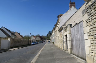
Chaussée Jules César
A Roman road
A Roman outpost...
The Chaussée Jules César was undoubtedly built in the 1st century. It was part of a vast network of Roman roads created by Marcus Vipsanius Agrippa during the reign of Emperor Augustus. This network was designed to establish Roman authority by providing access for soldiers to expand or pacify the outer reaches of the Roman Empire, and allowing travellers and goods to circulate with greater speed. The Chaussée Jules César is an offshoot of the
Via Agrippa de l'Océan, one of the four major routes in the Roman road network, linking Lyon (
Lugdunum, capital of the Gauls) to the English Channel via Paris (
Luteci) and Rouen (
Rotomagus, then the centre of the capital of the Veliocasses). In Vexin, the ancient route was a remarkably straight line over 52 km. Special arrangements allowed the road to traverse small streams and steep hills.
Various modes of transport were used. The less wealthy travelled on foot. Others travelled on horseback or in coaches. There were regular stops throughout the journey. Travellers could change horses at mutatios placed every 15 kilometres or so. These establishments also contributed to the speed of the imperial postal service, letters could be sent from Paris to Rouen in just one day.
… surpassed by new developments
Rouen continued to be a significant inland port, administrative centre and hub for the textile industry into the 18th century. The Paris-Rouen road was one of the country’s most important routes, linking two of France’s major cities, until the rise of Lyon and Marseille.
The old imperial road came straight into the village and in places reached 11% in gradient. An initial detour was built to go around the village bending for around 2.5km towards the south, on a less than 5% slope. While the detour satisfied travellers, it upset villagers, who once hired fresh horses to travellers trying to get up the hill. The regular stagecoach service disappeared in 1844, largely due to competition from the Paris-Rouen rail line, opened in 1843. The expressway opened in 1979. On this stretch it was downgraded to a regional road (route départementale 14) in 2006.