Prochain point : lat="49.054993" lon="1.815330"

Scenic Views Just Outside Paris
A hilly agricultural plateau
This is the highest point in the municipality of Lainville-en-Vexin, and from here unfolds a landscape typical of the Vexin plateau, interspersed with valleys at the bottom of which villages huddle together. The agricultural plain slopes down to the hills below, and features large parcels of grain crops. A few farm buildings are located on the edge of the fields. The landscape changes according to the seasons and the crops (canola, wheat, etc.) to reveal a mosaic of colours.
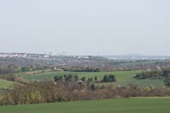
The village of Montalet-le-Bois occupies the floor of the valley. It is crossed by the Bernon, which rises a few hundred metres to the northwest. The small hill in the background is covered by three woods - Galluis, Jambville and Bruyères - that form part of the ancient royal forest of Arthies. On the horizon looms La Défense, about 40 kilometres away.
Montalet-le-Bois: in the Hollow of the Bernon Valley
The entire length of the village is organised around a main street. The old fabric is composed of rural houses and early small farms. Only the bell tower of the Notre-Dame church (twelfth century) and a few houses stand out from the foliage. The newer buildings back onto the hillsides.
The head of the Bernon catchment basin (a tributary of the Montcient) has experienced repeated floods and mudslides. Several homes have been submerged by the muddy waters, resulting in natural disasters being declared in 1997, 2000 and 2002. The clay and silty soil of the watershed are conducive to runoff, and modifications have been carried out to try to control the risks: storage pools and ponds have been created and hedgerows planted to temporarily hold back the heavy rains.
Lainville: Hidden on a Hillside
The village of Lainville, the suffix of which comes from the Latin ‘villa’, recalls an ancient human settlement from Gallo-Roman times, as confirmed by the discovery of a cemetery on the Menues Terres. Lainville was the possession of the seigneurs of Meulan in the ninth century. In the thirteenth, it passed by marriage to the La Roche-Guyon family; and in the seventeenth, to the Senneterre family followed, a hundred years later, to the Crussols, the last seigneurs of the village. Lainville took its present name on December 25, 1997 when it became Lainville-en-Vexin. The village is grouped around the eleventh-century Romanesque church dedicated to Saint Martin. The dense old buildings are made up of rural houses and small old farms. There are also two large isolated farms, Maigremont and Maléra, together with several hamlets: La Guillaumette, Les Bruyères, Les Bonnes Joies, Les Bouttemonts and Les Chayets. Newer houses have been built at Le Prieuré.