Prochain point : lat="49.079844999986818" lon="1.587693"

WATER
An evident resource in the village
The Epte and the Seine…
The Epte constitutes the western limit of the Yvelines and Val d’Oise Departments and that of the Region of Ile-de-France. After the signing of the Saint-Clair-sur-Epte treaty in 911 AD, it served as the border between France and Normandy, controlled by the vikings. The Epte flows for around 113 kilometres before joining the Seine. The Epte valley is a significant ecological site in the Paris Basin because it brings together a vast range of different natural environments. On the slopes and edges of the plateau, dry lands, such as alkaline grasslands and plantations of thermophilic trees can be found. While in the bottom of the valley, wetlands dominate, with alternating stretches of open prairies and treed areas. Situated within both the Epte valley and the Seine valley, the town of Gommecourt enjoys the benefits of both these kinds of landscapes.
The shape of hills and the availability of water determined where the inhabitants settled. The heart of the village grew up near the Epte, avoiding the flood plane. While, the hamlet of Clachaloze, developed along the banks of the Seine.
…small pieces of local heritage
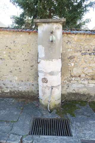
The town had two wells. The first was a communal well, located on rue de l’Eau, where you can still find a stone column from the old Clachaloze chapel. The well was once built against this column. A cast iron pump enabled villagers to collect water from around ten metres deep. Another well, this one privately owned, was also dug in 1833, in the courtyard of the farm at number
2 rue de la Côte aux chiens.