Prochain point : lat="49.014334" lon="1.95071"

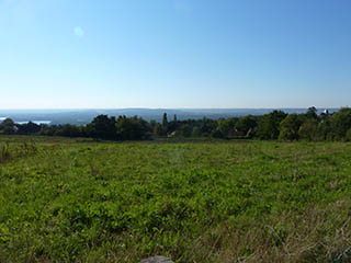
A panoramic view over the Seine Valley
Evolving spaces
The village of Evecquemont, 'episcopi mons' (bishop's mount or episcopal mount) stands on a hillside. Although human settlement here has been documented since Gallo-Roman times, the village really began to develop in the Middle Ages, growing up around the Notre-Dame Benedictine Priory, founded in 1119 by the Abbot of Fécamp. From the fifteenth and sixteenth centuries onwards, the village took shape around the seigniory. The houses, built with local materials (gritstone, lime and plaster render) were lined up along the village's two main streets, the Rue d'Adhémar and the Rue de Chollet. In the late nineteenth century, with the arrival of the railway, new buildings began to appear on the hillside, in among the gardens and the orchards.
Three hundred quintals of apples and pears, ten of cherries and five of plums were produced on the commune's lands in 1917. In 1939, production was diversified with the addition of peaches and raspberries. Thereafter, the foundry industry, the decline in farming, the abandonment of the orchards and the encroachment of wooded spaces caused the landscape to close in.
In 2010, the commune decided to promote local food production by relaunching market gardening in the area. An agreement was reached with an affiliated association, 'Jardins de Cocagne', which manages a hectare of land and produces vegetables that are subsequently redistributed to the inhabitants in organic baskets.
The Hautil Wood...
This wood is located on a spur overlooking the confluence of the Seine and the Oise. It consists mainly of oak and chestnut trees but ash, maple, birch, hornbeam, lime and aspen also grow here. The wood is partly managed by the Office National des Forêts (National Forest Office – ONF) as coppice and coppice with standards, as a result of which there are two levels of vegetation.
...and the quarries
Evecquemont is located on the butte témoin of the Hautil Massif, successively submerged by various seas, giving rise to the formation of layer upon layer of sediment. Gypsum, which was mined in underground quarries in the nineteenth and twentieth centuries for use as plaster, appeared during the Ludian period (37 to 33 million years ago). Over the entire massif, 800 hectares were mined until all such activity ceased during the 1980s. The many cavities left as a result of the mining make the massif extremely dangerous, with subsidence likely to occur. The natural disaster risk prediction plan (PPRN) therefore delimits the areas at risk, specifically the red zones where all construction and mining activities are prohibited. A municipal order forbids access due to the risk of subsidence. A side benefit of this, however, is that Evecquemont has been able to limit urban growth, thereby safeguarding a very qualitative green belt around the village.