Informations directionnelles
Emprunter la rue Dory jusqu’au lavoir qui surplombe la Viosne.
Prochain point : lat="49.15858" lon="1.93516"
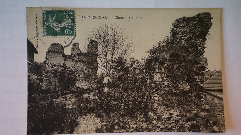
CHATEAU GAILLARD
Few traces in the archives
A fortified castle…
The Vexin region was at the centre of the conflict pitting the French monarchy against the English crown, conquered in 1066 by the Duke of Normandy, also known as William the Conqueror. As the two powers crossed swords, it became clear that defences were needed in the west of the French Vexin, and Chars is 20 kilometres from the most heavily fortified sectors. It is believed that a fortified house grew from a fortification on a mound at this time.
Tensions remained high throughout the 12th century and many villages in the north-west of the region were sacked and burned by the English in 1167. The presumed destruction of the castle that year prompted the scholarly Doctor Bonnejoy (according to a study on Chars in 1873) to claim it was rebuilt in 1199, when it got its name, Château Gaillard.
To protect Chars from plunder and pillage, Francis I of France granted the people of Chars the right to build a defensive fortification with gates protected by drawbridges.
…left in ruins
The castle is a rare regional example of this type of fortification. The surrounding marsh was intended to defend the castle by preventing any advancing enemy from undermining the fortification from below, scaling the walls or breaking through with artillery. It was ringed by trenches supplied with water by the Viosne. The fortification was protected by a polygonal enclosure topped by at least three towers. And we can still see some of the sandstone buttresses of the towers. The entrance was probably on Rue du Château-Gaillard. The walls of the dwelling were 1.50 m thick. It is assumed that a chapel and a hospital for the poor (known as a hôtel-Dieu) must have been located on the site, but it has not been possible to pinpoint where they stood.
A deed dated 16 July 1553 states that “the land and seigneurial estate of Chars, its appurtenances and outbuildings... hold and consist of a castle now in ruins ...”. This dilapidation was confirmed in 1586, when it was described as a manor house transformed into a farm, and in a parlous state, at the mercy of flooding. The outbuildings were destroyed by floods and had to be rebuilt.
The 1715 land register lists only a house, outbuildings, gardens and meadows.