Prochain point :
Orphelinat des chemins de fer
Prochain point : lat="49.08394" lon="1.875607"

Water
A village in the bottom of a valley
A former wetland...
The central part of the village is located on the site of a former marsh that was drained in the seventeenth century. The name 'Averne' hints at this abundance of water since it derives from the word 'vergne', which is the Gallic name for 'aulne' (elder), a tree that is often found on marshy terrain. 'Averne', then, would mean 'the place where the elders grow'.
Situated downstream from a vast drainage basin, the village of Avernes nestles at the bottom of a large valley carved out by the waters running off the slopes of the Buttes d'Arthies. The streams and springs were influential in the founding of the village.
...and water management
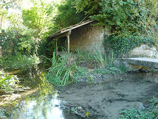
The village gets its water from three springs: Douée, Perreuse and Puits Perdu. They form three streams that flow into each other here, just before forming the Aubette Stream. This nineteenth-century wash house has retained its original architectural features. The wall of plastered stone and the sloping roof supported by cast iron pillars were added in 1884 to protect the washerwomen from draughts. The washing stones slope directly into the stream and the paved slope, forming a drinking trough, was designed for the livestock. The original ensemble was completed by the bridge over the Aubette.
The Auges Stream, which flows behind the church, provides water for another wash house and for the 'Mare au Prieur' (Prior's Pond). The village had several wash houses that remained in use until the mid-1970s.
In 1866, the municipality decided to equip the village with a drinking water network. Work to pipe the water from the Perreuse Spring to the pumps installed in the village began in 1868. In 1966, unable to meet demand, it was replaced by a new system on the Douée Spring that is still in operation today.